
As-Built Surveys & Scan-to-BIM , Precision 3D Measurement for Any Space
Whether you are renovating a listed building in Lisbon, documenting a logistics hub in Rotterdam, or planning a fit-out in Milan, accurate as-built data starts with a single site visit. Our LiDAR capture process produces E57 point clouds, 2D CAD floor plans, and Revit BIM models, ready for your design team within days. Coordinated from our Barcelona operations centre, with coverage spanning Western, Central and Southern Europe.
Trusted by Organisations in 12+ Countries
Architects, engineers, construction teams, facilities managers, and property owners across Europe trust our point cloud scanning to deliver the accurate spatial data their projects demand, from heritage buildings in Lisbon to modern offices in Berlin.












See What A LiDAR Scan Of Your Building Looks Like
The scan produces a high-density point cloud suitable for CAD and BIM workflows. Watch the flythrough to see how a single capture session generates the spatial data that architects and engineers across Europe use for design, documentation, and compliance.

Outdated Floor Plans Cost Projects Time and Budget
Across Europe, renovation and refurbishment projects account for over half of all construction activity. Yet the majority of existing buildings, from post-war office blocks in Frankfurt to Art Deco apartments in Barcelona, lack reliable digital documentation. Design teams inherit paper drawings, PDF scans, or nothing at all. The result is weeks lost to manual measuring, clashes discovered on site, and budgets stretched by avoidable rework. Point cloud scanning closes this gap by producing a millimetre-accurate 3D record of every floor, wall, and service run in a single visit.
Every Output Your Design Team Needs, From One Visit
E57 Point Clouds
High-density 3D data registered to survey control, compatible with Autodesk ReCap, Leica Cyclone, and CloudCompare. Ideal for clash detection, volumetric analysis, and as-built verification on renovation projects across Europe.
2D CAD Floor Plans (DWG/DXF)
Dimensioned floor plans, sections, and elevations extracted from the point cloud and delivered in AutoCAD-ready formats. Suitable for planning applications, fit-out tenders, and facilities management records.
Revit BIM Models (LOD 200/300)
Parametric models built to the level of detail your project demands. Walls, floors, ceilings, doors, windows, and MEP routes modelled from verified scan data, ready for European BIM mandate submissions.
Interactive 3D Walkthrough
A shareable digital twin that lets every stakeholder, from the client in Madrid to the structural engineer in Munich, explore the existing building remotely before design work begins.
Ready to turn your European building into usable design data? We handle the scanning, processing, and delivery, you get the files your team needs.
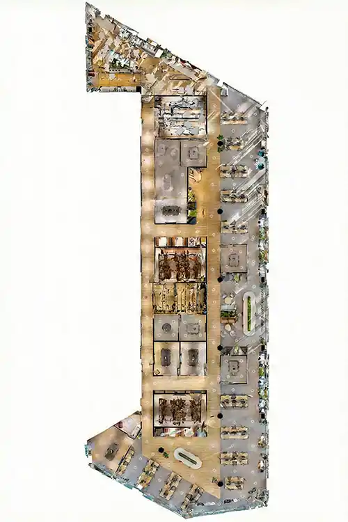
What You Can Extract From A Single Building Scan
E57 Point Cloud. The Raw Spatial Data
The high-density E57 point cloud captures every visible surface of your European building with millimetre-level detail. Use it directly in Autodesk ReCap, CloudCompare, or Leica Cyclone for measurement, analysis, or as the foundation for CAD and BIM modelling.
CAD Drawings. Plans, Sections, Elevations
We extract accurate 2D drawings from the point cloud data, floor plans, sections, elevations, and reflected ceiling plans delivered in DWG format. European architects use these as the verified base for design development, planning applications, and contractor documentation.
BIM Model. Revit And IFC
We model your building to LOD 200 in Autodesk Revit, capturing walls, floors, ceilings, doors, windows, and major MEP elements. Delivered in RVT and IFC format, the model integrates directly into European BIM workflows for coordination, clash detection, and design development.
Visual Digital Twin. Interactive 3D Walkthrough
Every scan includes a browser-based 3D walkthrough that lets anyone explore the building remotely. European project teams use this to communicate existing conditions to stakeholders who cannot visit the site, reducing misunderstandings and accelerating decision-making across borders.
Transparent Pricing for Sites
Point Cloud Scanning Pricing
Pricing depends on site size, scanning complexity, and the deliverables you need. Small commercial fit-outs and single-floor scans start from €484. Multi-floor commercial spaces and residential developments start from €1,478. Heritage buildings, large industrial sites, and multi-building projects start from €2,976. Final quote reflects scan area, point density, deliverable format such as E57, RCP, or PLY, and any modelling work needed.
How Point Cloud Scanning Pricing Is Calculated
Three things drive your final quote. First, scan area and complexity: simple commercial fit-outs scan quickly, while heritage buildings or industrial sites with dense MEP services need more capture positions. Second, point density and accuracy: standard surveys cover most needs, but tighter tolerances or higher LOD require longer scan time. Third, deliverable format and modelling: point cloud only is fastest; CAD drawings, BIM models, and Revit exports add modelling hours. Standard projects fall within the tier prices above; outside-of-norm briefs are quoted individually.
What Your Quote Includes
Every Point Cloud Scanning quote covers site survey planning, on-site scanning across the agreed area, registration and quality control, delivery in your chosen format, and any agreed CAD or BIM modelling.
Get Your Point Cloud Scanning Quote
Heritage buildings, industrial sites, and multi-building projects are priced individually. Send a short brief describing the site and you will have a fixed quote back the same working day.
What Clients Say About Working With Us
These reviews are pulled directly from our verified Google Business profile. Every rating is from a real client, see what architects, engineers, and property teams across Europe say about our point cloud scanning and Scan-to-BIM services.
Frequently Asked Questions About Point Cloud Scanning
Find answers to common questions about point cloud scanning and Scan-to-BIM services for European buildings, including deliverables, accuracy, timelines, and project suitability.
Which European countries do you cover for point cloud scanning?
We operate from our Barcelona hub and cover Spain, Portugal, France, Germany, Austria, Switzerland, the Netherlands, Belgium, Luxembourg, Italy, and the Nordic countries. For projects outside this standard zone, contact us for a tailored quote including travel logistics.
Does your scan data meet European BIM mandate requirements?
Yes. We deliver Revit models and IFC files structured to meet LOD requirements defined by national frameworks, including Germany’s BIM Stufenplan, Spain’s esBIM guidelines, and the EU BIM Task Group recommendations. We can adjust deliverable specifications to match your project’s compliance requirements.
How does cross-border VAT work for scanning services?
For B2B services between EU member states, we apply the reverse charge mechanism. This means no VAT is charged on the invoice, and your company accounts for it under your local VAT return. We provide all documentation your finance team needs.
Can you scan heritage or listed buildings in Europe?
Absolutely. LiDAR scanning is entirely non-contact. The scanner captures millions of measurement points using laser light, so nothing touches the building fabric. This makes it suitable for listed monuments, protected facades, and culturally sensitive interiors.
What file formats do you deliver and which software do they work with?
Standard deliverables include E57 point clouds, 2D CAD floor plans (DWG), and Revit BIM models (LOD 200 to 350). We also provide orthophotos, section cuts, and mesh exports on request. All files are compatible with Autodesk, Bentley, Graphisoft, and open BIM (IFC) workflows.
How quickly can you deliver scan data for a European project?
A single floor commercial space (up to 1,000 m²) typically takes one day on site. Point cloud processing and BIM modelling require 5 to 10 working days depending on LOD and complexity. Multi-building campuses are phased to maintain a steady delivery schedule.
Can you handle multi-site scanning portfolios across different European countries?
Yes, we regularly support property companies and facility managers documenting portfolios across multiple European countries. We coordinate logistics centrally from Barcelona, assign regional scan teams, and deliver consistent data standards across all sites.
Ready to turn your European building into accurate design data with point cloud scanning?
We Scan The Site. Your Team Gets Clean Data.
Point cloud scanning sounds like a niche engineering job. We have turned it into three steps that fit any project timeline.
1. Site Survey And Scope
Share the site, the accuracy you need, and the formats your team works in. We plan access, scan density, and any safety requirements before the day.
2. We Scan And Register The Data
Our team captures every area with LiDAR, then registers the scans into a single clean dataset, runs quality checks, and removes noise before delivery.
3. Delivered In Your Format
You receive the point cloud in E57, LAS, RCP, PLY, or whatever your CAD or BIM tools require. Your engineers, architects, or surveyors can start work the same day.
Tell Us About Your Building